Thursday, September 24, 2020

Lost Arch Hike II

Ha ha, so I did managed to climb down (stumble down) the steep rocks from Lost Arch (aka Dragon's Eye Arch) and live to tell the story. My astute readers figured this out right away, since I was able to publish the post. Seriously, this was a solo hike so I had to be extremely careful. Once safely down from the arch, I still had about an hour of daylight left. Lets do a little more exploring...

One nice thing about hiking alone is you can really focus on your surroundings. This trap door spider den blends in perfectly and would have been really easy to miss. Does it look like the spider jumped out and chomped off the end of my thumb??! Just kidding... No sign of the spider.

Exploring the wash below Dragon Eye Arch turned out to be very productive. This was mid-March, so lots of wildflowers keeping me company under a gorgeous sky.

X marks the spot!

Bird rock!

A beautiful little arch!


The Coxcomb Mountains off to the east serve as a great point of reference when hiking this area.

Space ship??

I believe this long, spindly plant is some kind of desert milkweed. I've never seen it flower before.

3 1/2 months later I came across identical plants in the same general area. The flowers were long gone, but these seeds were floating around, being pushed by the wind. Looks like milkweed seedpods to me!
 
Walking along, lost in my own thoughts and enjoying the wildflowers, I spotted yet another arch!
 
It's a nice one! From this angle, the rock is straight up and down so no chance to climb up for a closer look from here. But further ahead there is an area that allows me to circle around and get up to the arch from the other side.
 
As I get up to the arch, I catch my breath and take a second to capture the beautiful view. Below are shots from inside the arch.


I'm thinking of calling this one "Two Finger Arch" because, from the inside, it looks like a couple fingers hanging down.
 
One final view from atop Two Finger Arch. If I were to continue my journey, I would be hiking forward in the direction of view seen here. It's an area I have never hiked, and likely few others have hiked it, but it will have to wait for another day. I'm tired, hot, sweaty, and losing daylight. Time to start my trek back to the car.

Thanks for joining me on this adventure.
Stay safe and stay healthy!!
Linking with Skywatch Friday.

Monday, September 14, 2020

Lost Arch Hike

Allow me to escape back out to the desert for this post. Hiking in the middle of nowhere helps me clear my mind and, at least temporarily, forget about all the challenges and issues going on right now.

A number of months ago I had the opportunity to hike with Cousin Curt (Scott is the cousin I usually hike with, just to avoid any confusion 😉) and my friend P.T. 

That's Curt on my right (your left)... thanks to P.T. for the photo. We had a specific destination we were heading to and limited time. The route we were traveling was a new one for me.

So you can imagine my surprise when we spotted this arch on our hike in. It looks like a beauty, and I couldn't recall anyone ever posting a photo of it. However, our primary destination was calling us, and trying to find a way up to this arch would be a serious, time-consuming detour. I snapped this photo and we continued on, but I knew I would be back soon. I gave it the name "lost arch" just in case I couldn't find it again!

Fast-forward two weeks later...

... lets go see if we can find "Lost Arch"!

My search for Lost Arch took place in mid-March. An absolutely gorgeous day with some wildflowers to keep me company.

Echinocactus polycephalus
 

This heart-shaped opening in the rock caught my eye.
 
Luckily, I found Lost Arch pretty easily. As I would soon learn, the hard part wasn't finding it but getting up the rocks to get a closer look! As I climbed my way down the rocky wash in the direction of the arch, I soon lost sight of it. As I got to the area that should have been just below the arch, it was not visible. Also, the rocky hillside was very steep. Hmm, this is going to be harder than I thought! I ended up continuing down the wash, and circling around to the back side of the rocks before make my ascent.
 
Finally, there it is, dead ahead! Getting over these very steep rocks to get a closer look is going to be a challenge. I think my poor camera got a couple new dings on this hike.
 
Ah, that's better. I'm trying to get a good angle so I can see blue sky through the arch, but these steep rocks could care less about what I want!
 
I take a short break from the climb to enjoy the view looking north and to catch my breath. I saw no cars parked along Highway 62 (which is the norm), so I have this entire area of Joshua Tree National Park to myself!
 
I'm nearly inside the arch now, and yes, you guessed it. I wonder if I can get through the arch and get some photos from the other side?? This is when you wish you weren't wearing a backpack and a full-frame camera. Oh well, let's give it a try...
 
Success! I've just squeezed through the arch and this is the view from the opposite direction (looking west now).

A little further away from the arch, there's a small scraggly juniper somehow clinging to life on the rocks. It adds some color and interest to the photo.
 
 The arch looks dramatic in b&w, and notice the sun is starting to drop behind the rocks. I better keep track of time because I still have some exploring to do, and I need to figure a way down off these rocks!
 
One last shot of this beautiful arch. Oh, and wait a moment, let me get a couple more of the surrounding desert. For me, last shots are almost never last shots!
 
The view north. Just for perspective, that rock with the pointy nose is about the size of a bus. It's huge, and looks like it might slide down at any moment!
 
And a last view east, looking at the Coxcombs. This time with the Juniper in front of me and Lost Arch at my back. And an important note... I shared photos of "Lost Arch" with my friend Mark R. who's done a lot of exploring in this area. I was surprised that he had already found it, photographed it, and named it "Dragon's Eye" Arch!

So now it's time to see if I can figure out a way to safely climb down off this pile of rocks. I guess you're just going to have to wait until next week to see if I'm successful, and if so, what else I find in this area. Until then...
Stay safe, stay healthy, and thanks for stopping by!!
Linking with Skywatch Friday.

Thursday, September 10, 2020

Apocalypse Now?

"With ash dusting the Southland like snow, Labor Day 2020 has vibes of the apocalypse."
LA Times, Sept. 8, 2020

"I quite literally have no patience for climate change deniers. You may not believe it intellectually, but your own eyes, your own experiences, tell a different story."
California Governor Gavin Newsom
 
In related headlines...
National Forest Service announces unprecedented closures of all national forests in Southern California, including trails and campgrounds, amid scorching temperatures and extreme fire danger.
 
Woodland Hills reached a high of 121 degrees on Sunday, which was the highest official temperature ever recorded in the history of LA County.
 
Wildfire within the Mojave National Preserve ravaged the heart of one of the world's largest Joshua tree forests. The Joshua trees are not expected to survive.
Screen shot, LA Times, 9/8/2020
The National Weather Service is predicting hot, dry Santa Ana winds to begin later today (Tuesday), making this the worst potential wildfire season on record. As bad as the wildfires are now, they will get worse.

I could continue, but you get the picture. Things are not good here, and we're not the only ones struggling. I keep asking the question "how could things possibly get any worse?" I finally realize, I'm asking the wrong question. 

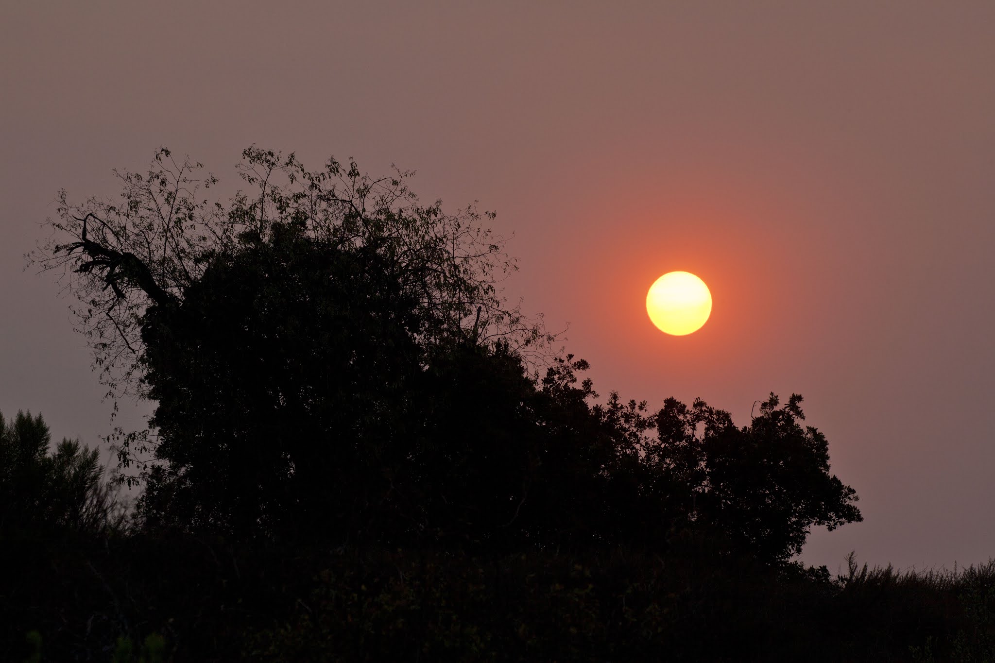
I went out for a walk last night after dinner. The sky color was very strange... Kind of a yellow-gray, with a dash or purple. The sun was a reddish color. I was walking in an area where few others walk, and wearing my mask. The mask wasn't because of COVID, but because of the unhealthful air quality. Ash falling from the sky may be toxic. You are not even supposed to get it on your skin, and everyone is being told to stay indoors if at all possible. So rather than breath in toxic ash and do irreparable damage to my lung tissue, I kept my mask on for the entire hike. In the photo above, the hawk on the pole seems to be wondering the same thing I was wondering: "What's going on with the world, and why does it look so different?"


Buildings, houses, concrete and asphalt for as far as the eye can see (which isn't far on this particular evening). Such a strange, eerie sky.
 
California's answer to the affordable housing problem has always been to build more houses. The spot where these photos were taken is one of the last remaining open spaces in North Orange County, but will soon be developed. More houses, more roads, more traffic, etc., etc. Personally, I don't think building more houses is going to fix anything. Quite the contrary. 
 
As the sun moved lower on the horizon, it started to disappear into the haze and smoke. But I managed to get this photo (using a telephoto lens) before that happened. It reminds me of some alien planet in a science fiction movie.

Another alien sun shot. So long, you strange looking sun. We'll see what tomorrow brings.
 
By 7:20 PM, half the sun had disappeared into the smoky haze of the sky. Or, I guess if you're an optimist, half the sun was still visible. Either way, do you blame me for wearing a mask over my nose and mouth?
 
 
Even with the yucky, smoky sky trapped under the clouds, the blue sky up above provides hope for a better tomorrow. One can always hope.
 
Linking with Skywatch Friday.
Stay safe & stay healthy!!


Thursday, September 3, 2020

A Quick Get-Away!

We had planned our quick get-away (two nights) in the Pismo Beach area for April, but had to cancel due to the pandemic. We rescheduled for late July, thinking things had peaked and were on a steady decline. Well, not exactly what happened, but the hotels stayed open, so we kept our reservation. It's weird trying to do a road trip these days, even a short one. Restaurants are either closed or open for take-out only (which is what we ended up doing), stores and roadside attractions are closed, etc., etc. Lot's of unexpected things seem to pop up. For example, with restaurants and stores closed, finding a restroom on the road becomes more of a challenge, especially if you are trying to avoid the grimy gas station variety.


The motel we ended up staying at has it's own private beach, which was beautiful and uncrowded. Only downside was navigating the 100 steps and steep walkways required to reach it. You need to travel light when you go to this beach! That's my wife with a sling to help carry our chihuahua, who has bad joints (but then again, so do we!). I was carrying beach chairs and towels. I can't remember what Lilly was carrying, but she had her hands full!


We have never taken a vacation with our dog before, but we figured with restaurants and shopping closed, this might be the perfect opportunity. We stayed at a dog-friendly hotel and everything worked out great!


Turns out the hotel's private beach also has it's own private arch. How cool is that?? You know me, I love arches! See that tree up on top of the hill above the arch? You will be seeing that again.
 
Yup, same tree. This is the view from our hotel balcony. Very nice! My wife took this photo of me taking a photo of the tree.


A very photogenic tree!
 
This photo is for you bird-lovers. The rocks in the area seem to be prime real estate for birds, with seemingly every available space in use. Near as I can tell, the birds are represented almost entirely by cormorants, pelicans and seagulls. The ocean in this area must supply an abundance of food! I think there is a lot of what they call upwelling in the area, which brings up nutrient-rich waters, which feed plankton, which feed small fish, and on up the food chain.
 
Day #2 we headed over to an area called Montana de Oro State Park. We spent a couple hours there, but we easily could has spent days exploring the area. It's truly beautiful, and there are many trails heading down to secluded beaches that can only be reached on foot. 
 
Panoramic shot of Spooner's Cove. Full disclosure: I edited the sky using Luminar 4 to add some color to an otherwise grey sky.
 
Lilly heading down to Spooner's Cove

My lucky day. We found another arch!!


Here's what the arch looks like at high tide. What a gorgeous shot! Photo credit goes to: LA-tr-road-trip-issue-photos-20160621-003 Baltimore Sun


Back at the hotel, it was time for take out. It was easy to socially distance at this small seaside hotel.
 
These little mini-vacations might be what we do in the foreseeable future. No planes, no boats, no tours, no large crowded motels or theme parks. Just quiet, low-key escapes 2-3 times a year. Perfect!

Linking with Skywatch Friday.
Stay safe & stay healthy!!