Thursday, October 25, 2018

Quail Springs Pump House

I think this location qualifies as one of Joshua Tree National Park's "secret spots". I won't give away the location other than to say it's a mile or less from Samuelson's Rocks (which is itself somewhat of a secret location). No signs, no trails, no mention in any NPS brochures. Just a water pump out in the middle of nowhere! I had seen pics and a blog post or two, and knew the approximate location, but it was still like looking for the proverbial needle in the haystack. After scouring Google Maps, I noticed a very small square object and thought that might be the pump house. Then again, it might just be a square rock!
We had some dramatic skies for the hike to the pump house. The hike also included a visit to Samuelson's Rocks and an old homestead location, but those have been covered on previous posts.

I think it's somewhere over there!!
 In our search for the pump house, we crossed this wash which contained all kinds of interesting old pipe and other debris. I knew something had to be "upstream" from here!

Eureka! We found it!! 


Cousin Scott checking out the pump and mechanism. It appears it might have been belt-driven, with a belt turning the wheel on the pump (left side) to pump the water.


The really cool thing about this pump is that it still works!! Move the pump handle up and down and it pumps water out the black pipe to the metal water holder you see here. There was water in the container and I'll bet critters come by after dark to get a drink here on a regular basis. I was tempted to taste the water but decided it might not be too clean once it passes through the rusty pipe. Had it been a typical hot desert day, I could have soaked my head with genuine Joshua Tree well water!

I'm sharing a video from my friend Elliot Koeppel's blog post, which you can check out here


I took my fisheye lens on this hike, so I'm required to share a couple shots. One is barbed wire in the Samuelson corral area, and the second is the signed rock. Such an interesting and bizarre area!

Time to start the hike back. Look at these beautiful desert skies!!

During part of the hike, you can follow the old double-track trail. But it disappears after a while.

A final parting shot.

"Leave only footprints, take only photos"
Linking with Skywatch Friday.
Thanks for stopping by!!

Thursday, October 18, 2018

Boy Scout Trail

I hiked Boy Scout Trail back in March with my cousin, and I must say, it was a very fun hike! It's been on my "to do" list for literally years. One of the really cool things about the BST is I can start the hike at the trailhead deep in Joshua Tree National Park and hike right to my house! It's also great to hike with my cousin. We share many of the same passions (including hiking and photography) and really enjoy each other's company.
BST is not a loop. You can either start at the trailhead in the Park (just off Park Blvd.) and hike mostly downhill to the end of the trail in Indian Cove (which is what we're doing today). Or if you're crazy you can hike it the other direction going uphill most of the way. It's best to get dropped off at the trailhead so you don't have to worry about going back to get your car once you complete the hike. Starting at the trailhead off Park Blvd., you hike in a northerly directions toward the town of 29 Palms and Highway 62 (see map). Our hiking path is the blue line on the map. Please ignore the straight diagonal line. Not sure what that's all about, but it wasn't us!

Cousin Scott at the BST trailhead just off Park Blvd as we begin our hike. We had a rare cloudy day which was perfect for hiking and actually had some light sprinkles for a while.

For the first couple miles, the hike couldn't be simpler... straight, level trail through the Joshua Trees. Probably too small to see, but there are three ladies climbing the big rock in the middle of the photo. Look closely and you can see one standing on top of the rock.

A little clearer view of the rock climbers.

Hi, Scott!!


After a couple miles the trail starts dropping in elevation and moving in and out of rocky outcroppings. It roughly parallels the Wonderland of Rocks on your right (east). You never get too deep into the rocky Wonderland, but you get a little taste!


Gnarly, Dude!

Much of the second half of the trail follows a wash.

Left or Right?? Take your pick, I guess!!

Old livestock watering trough found along Boy Scout Trail
Cousin Scott striking a hiker's pose!

From this spot on the trail, you get a sneak peek of 29 Palms beyond the hills of JTNP


This is, in my opinion, the best view you will see from BST. It's really stunning, with the rocky mountains of Joshua Tree all around you and the town of 29 Palms off in the distance. Most of the photos from this post were taken with my iPhone because I didn't want to get my DSLR out of the backpack in the light rain we had for much of the hike. From this vista point, the trail drops steeply down into a wash. It's in this area you start to think "I never want to hike this trail in the opposite direction!!"

Looks like this wash gets a lot of water from time to time.


Nearing the end of the trail, with some nice views of 29 Palms. To complete the hike, continue to follow the trail for about a mile NE to Indian Cove Road. Scott and I will hike straight ahead, down into the wash, and follow it N/NW right to our front door. Now that's a great hike!


Linking with Skywatch Friday.
Click on the link to check out great skies from around the world.
Thanks for stopping by!!

Thursday, October 11, 2018

Squaw Tank Area

Squaw Tank is one of the stops along Geology Tour Road (GTR) in Joshua Tree National Park. GTR is one of my favorite off-road drives in the Park. I've driven by Squaw Tank many times, and I've stopped a couple times to check out the "tank", but I've never really taken time to hike and explore the area beyond the tank. So I figured I was long overdue.
Hopefully you can see my little squiggles on this screen shot. GTR, which runs N/S, is easy to spot. Look closely and you can see the small turn off and parking area on the right side of GTR. Squaw Tank is a very short hike from the parking area. That's about as far as most people explore. Today's hike explores the prominent rocky outcroppings in the area (red circle). Side note: you can get to this area in a 2WD vehicle. Beyond Squaw Tank, 4WD is strongly recommended.

Photo of Squaw Tank, courtesy of my friend Elliot Koeppel over at http://cali49.com
I didn't come to check out the tank today, but I did want to check out a little-known and hard to see inscription that's on the dam.
Unless you knew this was here and you were actively looking for it, it's very unlikely you would notice the faint inscription:
Little William age seven
He died and went to heaven
We can't always sometimes tell
But Little Willie might have went to HELL

Who wrote this and when? Who was Little William?? Another of many bizarre desert mysteries, but it seems kind of mean-spirited to me. Can't help but feel sorry for Little Willie!

The first thing I did is hike up to the top of the boulders south of Squaw Tank. From this vantage point, there are some incredible views! In the photo above, looking SE, you have a beautiful view of Pleasant Valley and beyond.

I passed by this boulder on the hike up the hill. Kind of reminds me of a hippo. What do you think??

Looking north: Geology Tour Road, the turn off and parking area for Squaw Tank, and Malapai Hill

Looking south: the junction of Geology Tour Road


Interesting rock formation near the parking area. See the shelter?
Inside the rock shelter
Behind Squaw Tank. Look closely and you can see the top of the dam in the center of the photo.


Seemed like the further away I got from the parking area, the more interesting the rock formations got!

X marks the spot... rocky dike or intrusion in the granite.

Another little rocky alcove.
View from inside looking out of the alcove. Sorry about the foot!

Yet another alcove. This area seems to be full of them!

View from inside looking out of the Bat Cave!
Beautiful view toward Malapai Hill

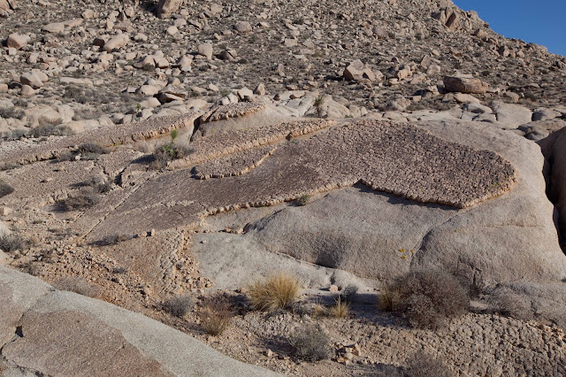
 I found it interesting how the cosmic stonemason seems to have laid these perfectly level sheets of rock over the monzogranite. Amazing!

Perhaps my favorite shot of the day. Something very calming about the location and the late afternoon light.

Sharp, rocky spires!


Joshua Tree with Malapai Hill in the background.
Linking with Skywatch Friday.
Thanks for stopping by!!
"Take only pictures, leave only footprints"