Does Joshua Tree National Park have it's very own "newspaper rock"? The "original" Newspaper Rock petroglyph site is in San Juan County, Utah. I've never seen the site in person, but here's a photo (by Stephen Cho, Google images). It looks spectacular! There are about 650 individual glyphs, and it's said to be one of the largest collections of petroglyphs in the world. In the Navajo language, the rock is known as Tse' Hane, or "the rock that tells a story."
So perhaps you will understand my scepticism. I was nearly certain there could be nothing remotely close to this in JTNP, or I certainly would have heard about it by now, or seen photos, or something!
About this same time, my friend Mitch asked if I would be up for a very challenging hike. He had recently hiked into a pretty and remote area in JTNP, saying it was about the most challenging hike he's done in the Park. That means a lot coming from Mitch, who's done some very extensive hikes, well beyond my ability. He said he **thinks** he might have found an easier way into the area. Oh, and by the way, we can go by Newspaper Rock. Ya, right. I reluctantly agreed, but secretly worried about not having the stamina to be able to make such a tough hike. The elevation gain was huge. The route was more than a little challenging, following a boulder-filled wash with multiple blockages and perhaps not even passable. And the total mileage was high. What if I get half way into this hike and am unable to continue? It's a real possibility, and the thought crossed my mind more than once. We would need to get an early start, because this hike would take a full day and a little more. So pull up a chair, get comfortable, and join me on what would become my most challenging hike ever.
We got an early 7AM. This after negotiating a little with Mitch, who would have preferred a 6 or 6:30AM start time, which seemed rediculously early to me. After finishing up our hike, his request for such an early start would make a lot more sense. Anyway, the hike would follow this wash for most of the way. Initially, it was easy going... just a slight uphill grade over a flat, sandy surface. Piece of cake, right?
But very quickly, the wash would narrow and rocks and boulders would be the theme of the day.
Early morning in the wash. This is perhaps the first of many (please believe me when I say MANY) blockages we would come across.
 |
| Mitch navigating one of the smaller, early blockages. |
 |
| Another blockage... |
 |
| And another. Are you seeing a trend? |
 |
| A "Mitch bypass" in action! |
 |
| First shade. I'm feeling spent, but I know we have a long way to go! |
A shy rosy boa. Not a great photo of him... he really didn't want to show himself, and we didn't want to bother him. I've never seen a rosy boa in the wild before, so this was a fun find. I have a fondness for them. My son had one as a pet for a number of years.
We finally, finally reach a plateau with a level view. An absolutely gorgeous area. We still have a ways to go, but at least we will be hiking and not climbing (for a while).
There are areas in this valley with abundant pinion pines. This area was trying to trick me into thinking I wasn't in the desert anymore!!
 |
| View through low hanging branches of a pinion pine. |
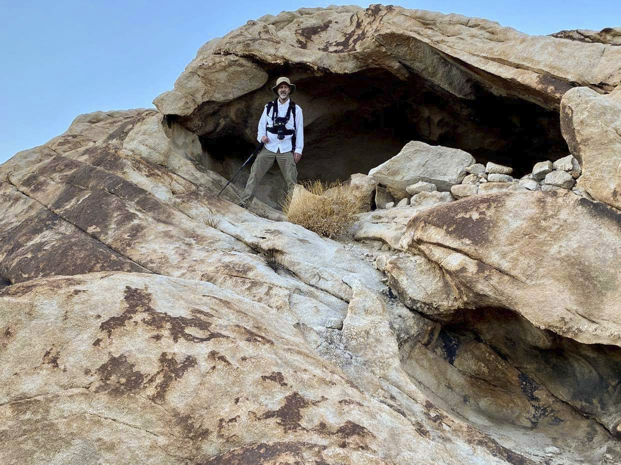
As we rounded a corner, my eye was immediately drawn to this strange circular design on a rock. It's located in a prominent spot, as if designed to call attention to the area. So of course, I went to check it out.
It's like a bullseye worn into the rock. It might even have a little cross design in the center, although hard to make it out. To my eye, it definitely does not look like natural erosion. This was made by Native Americans. As I was checking it out, I suddenly noticed the petroglyphs to the left. What a fascinating find! No way that I would have found these petroglyphs if the "bullseye" hadn't grabbed my attention and guided me here. Since the bullseye had called me over, and after finding the adjacent petroglyphs, I decided it would definitely be worthwhile to check out the area a little more thoroughly. That's when I found it...
WOW!! It does kind of resemble Newspaper Rock. Lot's and lots of petroglyphs here. Many appear to be faded and eroded away, but many can still be seen. The desert patina on the rock is light, so the glyphs are not as vibrant as Newspaper Rock in Utah. But impressive nonetheless. How come I've never seen photos or any reference to this site? Very odd. All I can figure is that's it's so remote and difficult to get to that few have seen it.
 |
| A strange wagon wheel with wavy spokes. |
One of my favorites is this "tally mark" pictograph. A little difficult to count the individual marks, but I keep coming up with 30. Coincidence??
I asked a friend of mine, who is something of an expert on cultural sites in JTNP, if he was familiar with a site called "newspaper rock". He said by reputation only, and that he had never actually seen it. He also said he had heard it's really difficult to get to (true). And he sent me a couple of photos of the site he thought might be the one I was referring to from archival files. It was a match! The site was documented by Daniel McCarthy in 1975, and he called it "Petroglyph Tanks", which is a pretty cool name, given there is an area close by that traps water (and many years ago likely had water year round).
 |
| I was amazed to find standing water in this area, even in a very dry year. |
A small amount of standing water in another area near Newspaper Rock (or petroglyph tank, take your pick). The rocks in this area are smooth and water-worn from many thousands of years of flash floods.
A bedrock mortar in the petroglyph tanks area. Look closely and you can see the grinding stone (pestle) was rubbed against the left wall of the mortar, as it's worn away at a smooth angle. The right side is straight up and down. The smooth rocks at petroglyph tanks turned out to be a challenging obstacle. Mitch kept getting to about this spot before sliding back down again. See Mitch smiling? He likes this route better, but I'm not convinced it's any easier. I think I required some help getting up this section.
As we started exploring the upper valley, we came across this old campsite. This area has been designated "day use only" (no camping) for a long time, so this is likely quite old.
 |
| Nolina |
This skull seems a little small to be a coyote, so I'm thinking fox.
Makes me wonder how it met its demise. Hopefully nothing too painful or violent, but nature can be both.
Wow, check that out! A perfectly formed arch on the hillside. It's further away than it looks, and it appears to be quite large. Not enough time to check it out today. There are very few arches in this part of the Park, and given its remoteness, I wonder if anyone has ever photographed it? My achy joints are telling me I will likely never do this hike again, but the opportunity to climb the rocky rubble over to that arch for some proper photographs is the one thing that might get me back.
Even though it's only mid-afternoon, we need to start heading back. Although I hate to leave this beautiful valley, no way do I want to be navigating this wash in the dark. See if you can spot Mitch in the photo below.
The hike back. We're exhausted, and a trip and fall is much more likely during this part of the hike, when leg muscles no longer obey commands from the brain. We completed the last 1.5 miles in total darkness, wearing headlamps and navigating by handheld GPS. Mitch was right. Should have gotten and earlier start!
If you've stuck with me on this long hike, THANK YOU!
A few hike details:
Straight up the wash, hike around in the upper valley for a bit, and then straight back down. Very symmetrical! Looks like total distance was 10.6 miles, which doesn't reflect the degree of difficulty of this hike. Total ascent: 1759 feet. That reflects the degree of difficulty! Also, the hike duration was 11 hours and 49 minutes. By far a new record for me, and I'm not exaggerating when I say it took close to a week for my aching joints to recover. But so thankful I was able to do this hike. Would I do it again??
😊