Thursday, March 30, 2023

Pushawalla Plateau

 It wasn't so much the distance (7-8 miles) that had me worried. It was the 1600' elevation gain. That's a lot for an old guy like me, and I joked with my hiking partner (who has summited almost every significant peak in the western US and for who this would be a "walk in the park") that he might have to push me up to Pushawalla. He laughed, but I told him I have serious concerns! As it turns out, after a tremendous amount of huffing and puffing, I made it. So pull up a chair and join me as I attempt this challenging and beautiful hike in Joshua Tree National Park!
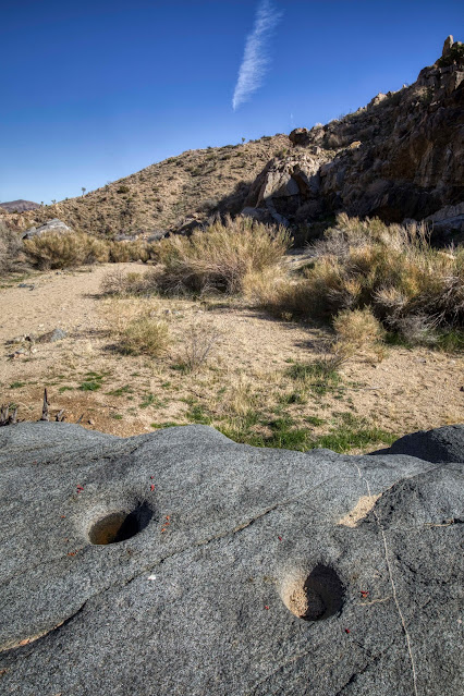
Native American bedrock mortars.

We spotted this weird buish rock with a pink stripe in the early part of our hike. It really stands out compared to the surrounding rocks. It would be fun to hear a geologist talk about this formation. Also, on the right side of this formation are the remnants of a paved road! Evidently, this wash was once used to travel up to the Pushawalla Plateau and down the other side to the Coachella Valley. Perhaps supplies were once brought in this way to the miners who once worked the area. Lots of history in these hills!
 
Mitch is anxious to get up to the Plateau, but I manage to talk him into following this old miner's road (can you see it?) and check out some of the historical remains. It doesn't add any extra mileage, but it does add some challenging terrain and requires extra time.
 
It wasn't long before we came across the remains of a stone structure. It's likely an old miner's cabin. This area is known as the Hensen Mining District. There are reported to be around 5-8 of these rock structures in the area.
 
There's a faint rocky rectangular outline with some rusty historic trash inside. Hard to say if there was a structure here.
 
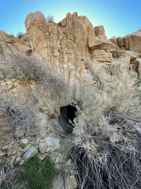
We come across a small mine.
 
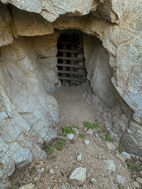
The Park Service has it gated off. I wonder how far back it goes?
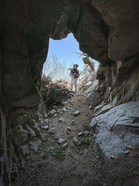
 
Inside looking out.
 
Cool find of the day! This is called a Chilean mill, and I had seen pictures of it and knew it was around here somewhere. Really pleased that I was able to find it. A Chilean mill is a big, heavy, round piece of concrete covered by a steel band on the outside (see photo below). It's used to roll over and pulverize rocks in the search for gold. There are only two of these in all of Joshua Tree National Park, and the second one is reportedly located somewhere in this area.
Photo credit: http://stampmillman.blogspot.com/2016/09/chilean-mills-and-their-origin.html
 
Two things caught my eye as we hiked past this pile of rocks. First is that the placement doesn't look natural. The boulders look like they were stacked here, although it would have taken tremendous strength and effort. Second was the old rusty chain. What possible use could it have??
 
Another stone structure. This one is the best preserved with the highest walls of any we would come across. It's hard to imagine what it must have been like for the miners living for extended periods in this remote and rustic location.
 
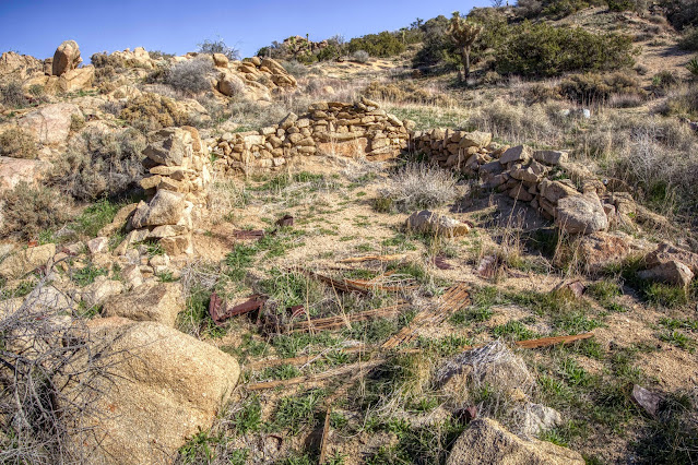
Three-sided stone structure remains.
 
Amazingly, we manage to find Chilean Mill #2! Mitch jokes that it looks like a headstone. The conversation goes downhill from there 😉
 
Further along on our hike, we come across the remains of a stone structure and some tailings. Someone must have been digging around here somewhere!
 
Sure enough, on the other side of the tailings, we find a mine. I think this might be the Pinyon Mine (sometimes called the Tingman-Holland Mine), or more accurately, an exploratory mine near the main mine, which has been filled in and no longer exists.
 
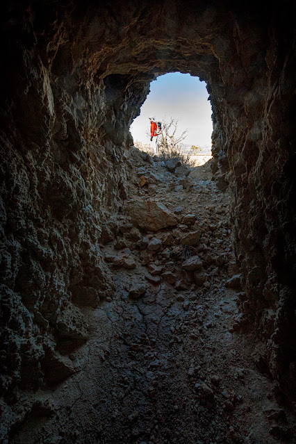
The view out. Hi Mitch!
 
We press on, and things get very steep and I'm huffing and puffing so much I can't even begin to think about taking pictures. But finally we reach what feels like a plateau. Thank goodness, because my legs feel like spagetti noodles and aren't responding to commands from my brain.
 
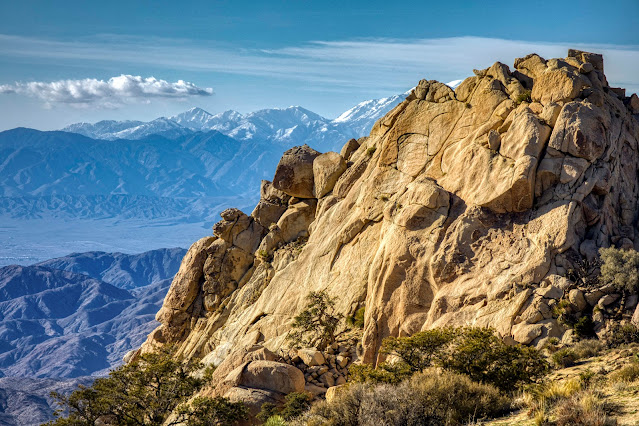
The views from Pushawalla Plateau are wonderful!
 

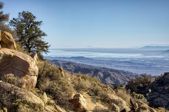
That's the Salton Sea
 
Mt. San Gorgonio on the horizon.
 

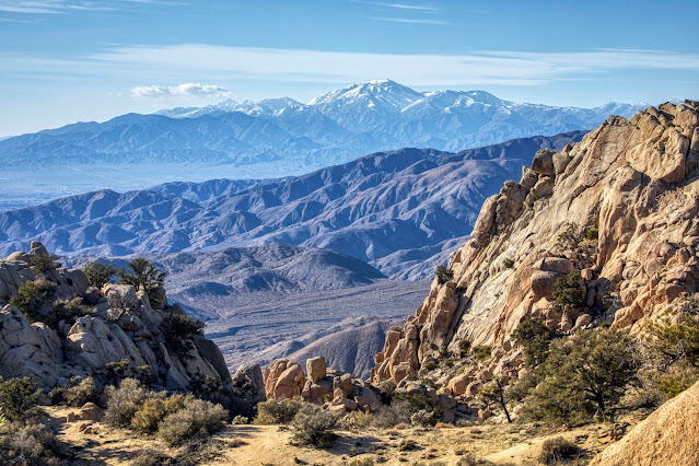
This is one of the views that most impressed us. The Pinion Pine in the foreground, with Mt. San Gorgonio in the background, makes for a wonderful photo. I could see the wheels turning in Mitch's brain as he said "how incredible would it be to be up here for the full moon setting over snow-covered San Gregornio, with that Pinion Pine in the foreground?" I could picture the photo in my minds eye, and yes, it would be incredible. Unfortunately, an impossible shot, because it would require making this very challenging hike in the dark in order to get up here a little before moonset (and sunrise). Impossible and foolhardy. Impossible??
 
Linking with Skywatch Friday.
Thanks for stopping by!!


Thursday, March 23, 2023

Bridge to Nowhere

 Still raining in S CA, and I think I read somewhere that the drought is officially over*. That little asterisk means "at least for now." I fully expect the drought to rear it's ugly head again in the not too distant future.
This little pop-up pond is probably much fuller today, but it's too muddy to hike there.


Fullerton Hills in the foreground, Catalina Island in the background.
 
Knotts Berry Farm in the foreground; big tanker ship on the horizon.
 
Lovely view of the sandstone cliffs.
 
The concrete road behind the chain link fence is a bridge crossing over the highway. I've been curious about it because I thought it might have some photographic potential, and also because it's labeled "Bridge to Nowhere" on Google Maps. With a name like that, how could you not be curious? Not sure how you place a public label using GM, but someone managed to do it. The bridge is fenced off from both directions, and the path on the other side of the highway doesn't lead to anything, so I guess "Bridge to Nowhere" is as good a name as any!
 
It's a beautiful bridge that I'm sure cost a lot of taxpayer dollars, but unfortunately the money was wasted and the bridge was never used. 
 
The city is serious about keeping people off this bridge, using chain link fence and ribbon wire as deterrents. Even with that, someone has managed to cut through the fence to provide access (nope, I didn't crawl through).
 

Padded bench for enjoying the sunset.
 
Even though spring is here, I'm happy with clouds and rain and hope it continues. A multi-year drought makes you appreciate this kind of weather!
 
Linking with Skywatch Friday.
Thanks for stopping by!


Thursday, March 16, 2023

Somewhere in the Pinto Basin

 A Facebook friend (J.A.R.) was kind enough to share a general location where he had come across some Native American pottery sherds. As I write this post, I'm wondering if I ever went back and thanked him for the tip? It was a good one, and we had a wonderful hike. Join me as we go see what we can find.
It was one of those beautiful, cloudy desert days. The smell of wet creosote was in the air. Nice and cool for hiking, but you need to keep an eye out for thunder storms and flash floods. It had already been a memorable drive out, with gorgeous skies and rainbows (see last week's post).
 
Looking in the other direction from the photo above, you could see some blue sky. The ocotillo were happy.
So were the smoke trees!
 
Here's a strange looking ocotillo. Usually their branches are more straight up and down. And this one looks almost purple in color!
 
Ocotillo only leaf out immediately after a rain. The rest of the time, they look like bare sticks coming out of the ground. The casual observer would understandably assume the plant is dead, but give them a little rain and magic happens! In the Pinto Basin of Joshua Tree National Park, these guys go for months and sometimes years without any rain.
 
After a long hike, we finally reached the base of the mountain. This spot looks like it might have been used as a shelter (I'm standing inside, shooting out). 
 
As I search for pottery, I feel as if I'm being watched!
 I find no pottery, but my first thought upon seeing this boulder is that this might be a pictograph. The marks look like they might have been made using dye. Here's what it looks like using dStretch (color enhancer).
It looks fascinating, but I suspect it's made naturally somehow (not a pictograph). It has direct sun exposure, and a pictograph would be totally faded. But it sure makes me curious as to how it could have been made.
 
It's not long after reaching the rocks that we start to see pottery.
 
More pottery and a rock chip that indicates tool making.


Fooled me... this is not pottery.

In the same general area I find two bedrock mortars that would have been used for grinding. This is turning out to be a very significant site!
 
My friend Roger finds a petroglyph panel. Very cool!
 
More petroglyphs near by.
 
This large petroglyph panel is so faded that we almost miss it!
 
More faded glyphs that we very nearly miss.


We find a few flowers and some colorful lichen while out exploring. And also some rain!


Roger and Mitch came prepared for the weather!
 
This turned out to be a very memorable hike, and what I consider to be a significant cultural site, with lots of pottery, petroglyphs, stone flakes, and a grinding site. Please please please if you come across a cultural site leave everything exactly as you found it. Take nothing, and leave only footprints.
 
Thanks for stopping by!
Linking with Skywatch Friday.