Thursday, May 6, 2021

Bookend Arches to Majestic Arch

 With my last post, I left you with some photos of Alien Arch and the surrounding area. You might recall that we discovered a couple arches we called "bookend arches" right at the end of the hike (not enough daylight to go check them out). But I had been itching to get back to the area to see if there was any way to get closer to them. Finding new arches is always an exciting discovery!
This photo of "bookend arches" was taken using a telephoto lens, so things are further away than they look. Also, I figured at best a 50/50 chance that we would be able to hike/climb the rocks up to the arches. Fast forward a few weeks, and I've managed to talk my hiking partners Mitch and Roger to join me on the search for these newly discovered arches. So off we go!
 
Hiking up and around the rocks to bookends arch turned out to be harder than I expected (pause here while I huff and puff). Here's Roger and Mitch as we stop for a water break. Arches that are visible on the horizon often disappear when you get below them, but we know there are some arches around here somewhere!
 

No arches yet, but the weirdly eroded rock formations are always entertaining!

I'm always amazed by how much lichen I see out in the desert. My assumption that lichen only thrive in moist environments is clearly flawed!
 
 
Finally, we find what we think is one of the bookend arches. This is viewed from the opposite direction of photo #1 of this post. It's pretty interesting looking, and there are little horn projections at the back of the arch. Maybe "devil arch" would be a better name! There should be a second arch if one were able to climb up and over the rocks on the upper right of this photo (good luck with that!). It also looks nearly impossible to climb up to this arch for a closer view. But that doesn't keep Roger and Mitch from trying!
 

I have no idea how Mitch managed to climb up there. All I know is it's beyond my abilities!
 
Close-up of bookend (or devil) arch.

For most of our hike, Majestic Arch has been keeping us company off to our right. We discuss the possibility of hiking up to it from this approach. I've hiked up 2 or 3 times before, but always from the opposite side. I have my doubts about this approach, but we decide to press ahead. Heck, what's the worst that could happen? Nevermind, let's not go there.
We start picking our way around the car-sized boulders towards the arch.

We eventually make it. Top of the world!

Ahhh, there it is. Majestic Arch! My favorite arch in Joshua Tree National Park, and one that very few people have seen because it's so dang hard to get up here (plus it's in a very remote location where only crazy people go... you've been warned!).
 
From deep within the arch... looking out through the arches two openings always reminds me of looking through the eyes of a dragon. The tupperware container with the register inside (red lid in the photo above), placed here by Mitch a couple years ago, was still here. The last people to sign in were friends of ours who we knew had visited, and that was over a year ago. Clearly no random hikers seem to find this place, and that's fine with us!
 

iPhone pano shot.


It's like a rocky wonderland up here by the arch, and even though there is near constant wind and near zero rainfall, there are a few hardy plants that manage to survive.


You can call these critter burrows. I call 'em ankle twisters!
 
Hope you enjoyed this adventure. Majestic Arch is a magical place, and I hope to return again in the not-too-distant future.
Thanks for stopping by!
Linking with Skywatch Friday.
 

I can tell you that it felt like much further than 5.6 miles, and much more elevation gain than 705'. I wonder how accurate these phone apps are??


Thursday, April 29, 2021

Alien Arch

 This hike started out as an exploratory hike into a trio of washes in east Joshua Tree National Park that was new to us. When I say "us", I mean Mitch, Roger and myself.

It turned out to be a beautiful day for a hike, with all the expected weird rock formations, and the Coxcomb Mountains keeping us company just a little ways off to the east.
 
 
When I say "hiking", it also includes a fair amount of climbing. Here's Roger climbing up a sheer rock wall (sorry about the sun flair).
 
And then looking down at me, as if to say "OK, your turn!" Nope, no way, not going to happen. I swear Roger is half mountain goat! I, on the other hand, am not as sure footed and am not a big fan of heights. In hikes like this, it's important to know your limitations!
 
In a world of strange rock formations, this one's really strange. Kind of phallic-looking. See the moon?

Mitch in his element.
As we get to the end of our hike, we still have some daylight hours left. There's an area nearby I've wanted to explore. I have a planned route that passes through a narrow wash (at least I hope it's passable). So off we go!
 
Here I am making my way through the narrow wash. I had to laugh at this photo because it reminded me of all the preparation that goes into a hike. You try your best not to forget anything. Backpack? ✔ Camera gear? ✔ Water? ✔ GPS? ✔ And the list goes on and on. For this hike, I remembered everything... except my hiking boots!! Geez, that's a first. A long gruelling hike in my slippery, flimsy street shoes. Not ideal.
 
Baby arch and sun flare.
 
We discover this really cool-looking rock formation, and Mitch has figured out a way to climb up to photograph it.

From this angle, the opening in the rock looks like an "L". I look closely for any sign of rock art, but I don't see any.
 
Mitch out exploring. The sun is getting low on the horizon... my absolute favorite time for photography!
 
A nice little cave.

And inside the cave, looking out.

Ah, there it is. Alien Arch!!
 
Such an incredible rock formation! See that alcove to the left and behind Alien Arch? Let's go check it out. 
 
Not an easy climb.

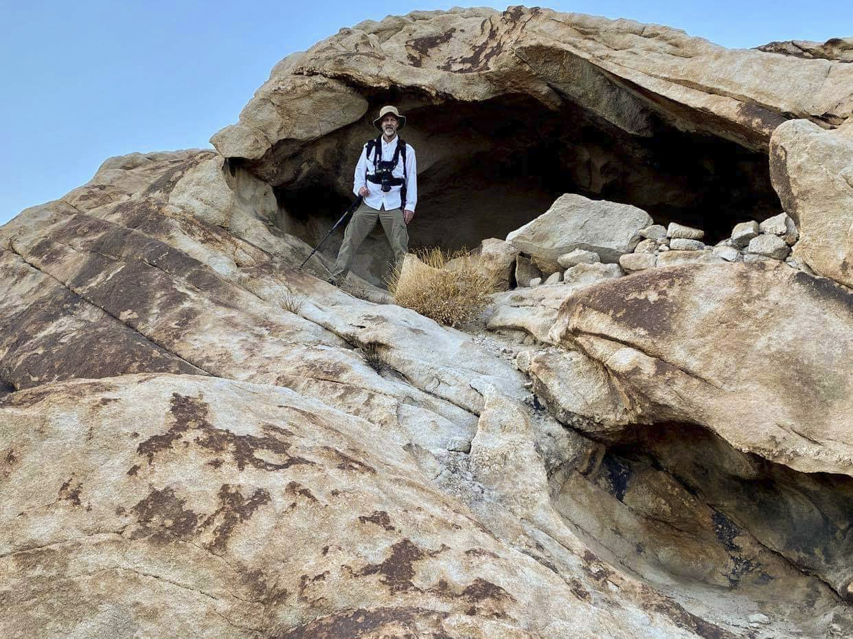
Those rocks to my left appear to have been placed there to make a partial wall to protect the shelter. Whether in recent times or long ago, it's impossible to tell. Photo credit above two photos: M. Miller

Inside, looking out. Lots of room in this alcove.

After finally making it up the narrow wash, it leads us to this upper wash area. It's an area rarely visited, and I would love to explore more, but unfortunately it will be dark soon. But just around the next corner we see...
...two arches! If you are an arch lover like me, this is a big deal. I wonder if anyone has ever photographed these arches up close before? Distance is deceiving because the photo was taken using a 400mm telephoto lens. It sure looks like two arches to me, one on either side, kind of like bookends. I immediately start talking with Mitch about a return visit to see if we can somehow hike/climb up to "bookends arches". Stay tuned!
 
I think we finished up this hike in the dark (wearing headlamps), which is usually the sign of a great hike!
Until next time, thanks for stopping by.
Linking with Skywatch Friday.

Thursday, April 22, 2021

WW2 Bombing Range

 One of the things I love about blogging is meeting people out there in the blogosphere with similar interests (fellow desert explorers). Some become virtual friends, while others have become hiking partners and true friends in the traditional sense of the word. One person who I've hiked with, and hope to hike with again, is a true desert explorer and a wealth of information. He mentioned an old WW2 bombing range within the boundaries of Joshua Tree National Park, and I was totally intrigued. First of all, I had never even heard of it. If I've not head of it, then it's likely one of those "secret" places that few have seen. Second, it's a very short hike (about a mile or so), so I thought it might be fun to take my wife and granddaughter to see what we could find. My friend said he was able to research the site and found it was used between 1944 and 1946. Dummy bombs would be dropped on an area as target practice in order to hone the skills of pilots and improve accuracy. The dummy bombs were made out of metal (likely full of sand) and had "spotting charges" (a small explosive used to help spot the point of impact).
In preparing for a visit to the location, I spent some time studying Google Earth. If there are any bombing practice remains, they must be small. I couldn't see anything that really stood out. However, I could see what might be the remains of curved lines in the sandy soil (yellow arrows, above) making a kind of bullseye target. The WW2 pin would be close to the bullseye center. Pretty cool!
 
As we started our hike, I challenged my granddaughter: "Let's see who can find the most bomb remains!" That got her interested.
 
Ta da!!! Lilly finds the first scrap metal, which we assume is the remains of a practice bomb. It has a nice rusty desert patina and looks like it's been sitting here a long time. OK: Lilly, 1; grandpa, 0!
 
But not everything had a happy ending on this hike. See my wife on the horizon in the photo above? She's exploring and also carrying our dog. We brought our chihuahua with us on the hike, thinking she would enjoy it. But shortly into the hike, she didn't want to walk any more, so we took turns carrying her. Not long after this photo was taken, my wife stepped on top of a burrow. Her foot sunk deep into the sand, she lost her balance, but as she fell, she wanted to hang onto the dog to protect it. She ended up landing on her right shoulder. We would later learn that she fractured her shoulder, along with other complications (I'll spare you the details). Thanks goodness she's doing better now. The shoulder is healing and she begins physical therapy soon.
 

Hard to tell what shape these practice bombs were prior to being dropped out of a plane, but they sure are mangled!
 
My wife found this desert tortoise shell. Some of the pieces of armour (called scutes) have fallen off, leaving the white subshell. I always feel a little sad coming across these. It's very rare to see a live one, although years ago they were common. They seem like a species right on the brink.
 
We came across this old amber jar. What's it doing out here?? (photo by Lilly)
 

We found these old rusty buckets in the area.

Bottom view: Something about "Steel Container Co", Made in Chicago, and patented in 1943.

See the "W" carved into the top of the bucket? Just a guess, but maybe water storage? Water could have been cached out here. Perhaps soldiers were stationed out here during the practice runs to record bomb drop locations.
 
A good time of day for a shadow selfie!

I have no idea!


Thanks for stopping by. Stay safe & stay healthy.
On, and no more hikes with our chihuahua!!
 
Linking with Skywatch Friday.