On my last post I shared the experience of finding something that looks interesting on Google Earth but maybe not as interesting when seeing it at ground level. You just never know. That's OK because you ALWAYS find something interesting in the desert no matter where you hike. Today's hike turned out to be similar: Interesting when viewed from space but meh when viewed from the ground. It's in the same general location as my last hike, but with an excursion further east.
I had discovered an area using Google Earth that looks a little like an ancient shoreline. Who cares about an ancient shoreline, you ask? Good question. Finding ancient shorelines in the Pinto Basin of Joshua Tree National Park has in the past been a productive way of coming across interesting Native American cultural sites going all the way back to the research by the Campbells in the early 20th century. This was a real long shot, but it intrigued me and I figured it was worth checking out. The other plus was I had never hiked to this area (likely not many others have either).
There's only one problem: I calculated it would be close to 12 miles round trip, which is pushing my upper limit of how far I'm able to hike. Hot weather was a factor too, and I would need to carry a lot of water.
**Side note**
If you give me a choice between 12 miles in the open desert (no trail, dodging boulders and cactus, soft sand, climbing in and out of washes, etc.) and 15 miles on a trail going through the forest with similar elevation changes, I'll take the 15 miles any day of the week. Much easier to follow an established trail and far fewer obstructions and detours. I thought about doing an over-nighter and spliting the hike into two 6 mile segments, but decided against it.
So I had two clear goals for this hike:
1] Visit what I called "No Name Arch" in my last hike and see if I could climb up to it, check it out, and get some good photos. By the way, a reader suggested "Elephant Head Arch" and I can see the resemblence, so I'm going with that name. Thank you!!
2] Time and energy permitting, head east to the "Ancient Shoreline" (if that's what it turns out to be) and explore the area.
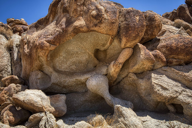
On my way to re-visit Elephant Head Arch, I found another arch! Not too surprising, as there are many interesting arches in this area.
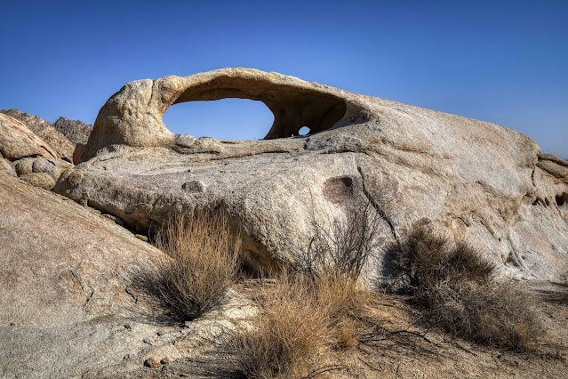
There it is... Elephant Head Arch. Hmm, the climb up looks a little more challenging than I recall 😟. Well, let's take it one rock at a time and see how far we can get.
I made it! I'd like to try to climb up and get inside the arch and look out the other side, but the granite is steep and smooth. Let's give it a try.
Success! This is the view from inside the arch looking east.
One last photo of Elephant Head Arch before I start the challenging climb back down. My 4' hiking stick is in the foreground for size perspective.
Back down safely off the rocks and in the wash below, I come across a group of tall, spindly plants. I only find these "plants" (they often look like bare dead sticks coming out of the ground) out in NE Joshua Tree. They are usually 6' - 10' tall, and these caught my eye because they are flowering! I think they are some kind of desert milkweed, and you can see flowers and seedpods in the photo above.
This tall, stick-like plant actually has pretty flowers, and it's unusual to see them in bloom.
 |
| The strange, twisted, tortured rock formations keep me coming back to this area! |
These desert tortoises have a very tough life indeed. I rarely see living tortoses, but come across their shells (like the one above) on a regular basis. Kind of sad.
I've made the decision that I have the time and energy to go check out goal #2: The ancient shoreline. I'll be traveling E/SE (toward the Coxcombs), and I've come across this odd clearing, and wondering why nothing is growing here. Was vegetation scrapped away at some point? And what's that line on the right that looks like a game trail or native trail? I have no answers but plenty of questions!
 |
| What's left of someones dinner. Rabbit bones, perhaps? |
It's a barren, bleak landscape. I've decided to go a little further, following the rocks on my right to the SE, until I have a clear view of the southern end of the Coxcombs and the Pinto Basin to the south. It's been a long time since I've seen any human footprints, and this area is rarely visited.  |
| Strangely eroded rock wall. |
 |
| Early tablet prototype! |
 |
| Snaggletooth monster! |
 |
| Hello old friend! |
small.jpg) |
| I'm falling!! |
Thanks for joining me on another adventure. No ancient shoreline, but a fascinating and remote area!


small.jpg)

Fascinating formations!
ReplyDeleteSuch interesting rock formations.
ReplyDeleteThat was quite an outing with lots of up and down. Climbing over rocks is hard as well.
ReplyDeleteYou have a great eye for interesting rock formations and I still admire your willingness for adventure.
Your photos show such fascinating rock formations and natural sculptures. Snaggletooth especially caught my attention. He seems from another age or planet … would be tempting to walk right into that mouth. :)
ReplyDeleteThere are some strange and eerie formations there! Its good that only an intrepid hiker like you can get there, because if it were easier this area would probably be a National Park and overrun. Elephant head (formerly known as No-Name) is perfect for that particular formation and there are several others you saw for the first time on this hike that I'm surprised you didn't name!
ReplyDelete...it's difficult to believe that this dry, barren place was ever a sea or lake. I would never be able to hike 12 miles in the open desert, I glad that you took me along to enjoy the sights.
ReplyDeletethanks for another fascinating trip
ReplyDeleteThe natural formation of the stones is really a wonder.
ReplyDelete12 miles in hot desert? You´re very fit, I so couldn´t do it. Fantastic rock formations as usual. Wonder what Native Americans thought about those. Perhaps something similat to you.
ReplyDeletewonderful place, Great pics. Thanks a lot for sharing.
ReplyDeleteAppreciate your stamina to hike these many miles. These wonderful sights are enough motivations to try these adventures. Lovely pics as always!
ReplyDeleteI thought Randolph Scott might pop out from behind one or two of those arches. Seriously, a fine post. It was a long, full, excellent day for you.
ReplyDeleteWhat can I say other that beautiful. I saw a couple of elephant arches along with a tortoise head, rabbit crab and monsters emerging from the ground. Just awesome
ReplyDeleteAmazing rock formations! Wow!
ReplyDeleteThe Elephant Head Arch makes for fascinating photos. Of course, you find such interesting features on all your walks... A hike that length would take a lot of working up to for me.
ReplyDeleteThat's a long way to walk and not find what you were looking for! However there were ample compensations along the way in the form of those amazing rock formations. I presume that tortoises usually hide away from the heat of the day and an unlucky few get caught out.
ReplyDeleteThe caves, the arches and the desert are very special parts of nature. I like the desert flowers.
ReplyDeleteAs always great shots!
Wow, so many amazing rock formations. They certainly get your imagination flowing. Thanks for sharing such incredible and beautiful photos.
ReplyDeleteI love stuff like this: the exploring, speculation. But how hot was it? I can't imagine the heat. Thank you.
ReplyDeleteThat new arch that you found resembles the crest of a dragon or a T-rex. :)
ReplyDeleteYou got some super interesting photos of rock formations on this journey. Well done. Seeing and capturing the tall spindly flower was also a marvel. It is quite pretty and so amazing to find it growing in the heat of the desert.
ReplyDeleteWhat a collection of rock formations. My favorite is the strangely eroded rock wall.
ReplyDeleteThose are some interesting looking rocks. You saw quite a bit that day.
ReplyDeleteThank you so much for all these fabulous pictures. They really light up your imagination, I saw all kinds of animals this time, strange ones. Loved this post.
ReplyDeleteThis is a great post. You found so many interesting arches, rock formations and rock wall on this hike. Have a great weekend.
ReplyDeleteWow! congrats on doing both trails ~ both very fascinating rock formations and fantastic photography ~ can see why you would keep going back to that one very different rock formation ~ Wow! again ~ Xo
ReplyDeleteWishing you good health, laughter and love in your days,
A ShutterBug Explrores,
aka (A Creative Harbor)
Dearest Peter,
ReplyDeleteGreat that you managed to do them!
You did as many hours hiking as I did driving on each day out West...
Those rock formations have so many questions for us, one really wonders how they came about.
No, it does not look like a shore line to me either!
Hugs,
Mariette
Interesting formations. Many of them look like they were shaped by water.
ReplyDeleteWow--those rock formations looked like gnomes! So many fascinating shapes. This area very well could have been underwater once. I learned that much of the front range of Colorado is former shoreline wot a large sea that existed here millions of years ago. That is why we have preserved dinosaur prints in many of our hogbacks as they were left behind in what was once sand.
ReplyDelete